Mount
Bogart
attempt
(west ridge)
–
September 4, 2004
Mountain height: 3,144
m (10,315 ft)
Elevation gain: approx. 1,350 m (we came up approx. 400 vertical metres short)
Round-trip time: 8:45
Descent time: 2:20
Scrambling
with Linda Breton and Kevin Barton.
Drew's
account:
When Kevin
called me the night before and suggested we try the west ridge of
Mount
Bogart
from the Smith-Dorrien road, I
couldn’t pass up the opportunity. Using this route would eliminate the lengthy
and tedious 11 km approach along the Ribbon Falls Trail (replacing it with the
shorter and more scenic route via Sparrowhawk Tarns), cut the elevation gain by
about 300 vertical metres, and possibly provide a more interesting ascent up the
west ridge (instead of the southeast scree slog).
Linda and I,
therefore, put our plans to attempt
Mount
Murray
and Cegfns on hold and the three
of us headed to the Sparrowhawk parking lot. Although we started the trip under
cloudy skies, the forecast promised a mostly clear day and so we fully expected
to see the sun for the better part of the ascent and descent. The 5 km hike to
Sparrowhawk Tarns was easy and became increasingly more scenic and interesting
as we passed in between
Mount
Sparrowhawk
on the left and Red Ridge to our
right. Given the large amount of precipitation over the previous two weeks, we
expected a fair amount of snow and we got exactly that….and a little more!
Once in the snow, we were very lucky (or unlucky, depending on your perspective)
to find several tracks of bear footprints. They were at least a day old and
were, fortunately, heading in opposite direction we were traveling.
From the
tarns, there were a couple of options to gain the ridge. We took the obvious
east slope. It was also the shortest route and in hindsight perhaps the only one
that would that got us to the ridge without some intense downclimbing or
rappelling. The slope was not terribly steep, but was a little exposed in places
due to the snow cover. Kevin and I tried a couple of routes up steeper rockbands
to the right without success. In the end, we ended up traversing the entire
slope to the col.
Unfortunately,
the col would prove to be the end of the line. Visibility was low (the summit
was completely enveloped in clouds), winds were high, and the temperature had
plummeted. Since we couldn’t even see the route up the west ridge and our
summit view would have been non-existent, we decided to retreat and return when
conditions were better. The descent was easy and uneventful. Overall, a good day
out, however, it was extremely frustrating to have such dismal weather
conditions, when good ones were forecast. You’d think by now I’d have
learned to be a weather pessimist ... apparently not!
Linda's
account:
The West Ridge of Bogart - Sept 4, 2004
In an unexpected twist, early Saturday morning, I accompanied
Andrew Nugara and Kevin Barton, destined for some vague snowy 'scramble' route
up the west ridge of Mt Bogart, as approached from the Spray Lakes side of
things. Umm...what?! I had been dreaming about a multi-peak day on my
way out, but snowy conditions were chasing those ideas away quickly. In truth,
I was relieved to be doing any kind of summit attempt.
From Spray Lake, we made our way up the long valley to Sparrowhawk tarns, and
encountered punishing deadfall for a nasty stretch (take the left fork, not
the right). Then there was the three boulder fields, snow covered for our
entertainment. Later, the snowy meadows, complete with upright alpine flowers,
and verdant-edged streams, were peaceful contrasts to what we had just
crossed. Looking in the direction of our objective, impenetrable cloud hid any
view of Mt. Bogart.
The snow deepened and it became apparent we were tracing the descent route of
a grizzly bear. Wait..make that three grizzlies. They traversed the high
and steep pass between the mountains from the Ribbon Creek area to head
towards Spray Lake. It was an awe-inspiring and humbling moment for me. And it
must have inspired a little fear, for a three-bear nightmare
was to plague me later.
At the tarns, a polar wind whipped, and we began the steep ascent along
the rock wall. The angle of the snowslope we were traversing continued to
increase at an alarming rate, until at its most inclined point, it crossed
above a soaring cliffband...oh good. We attempted to bypass this treacherous
slope by climbing a gully of odd rock steps. These turned out to be
deceivingly loose and steep. We abandoned that route cautiously.
Then the enterprising Kevin Barton raced up the next gully, by himself, to
check out its potential. I was impressed by his unbridled sense of
exploration; it was, afterall, his idea to do this route solo today. Now the
poor guy had me tagging along. Fortunately, Kevin also is a good natured
person, and seemed to be having fun the entire time we were getting blasted by
early winter. He scrambled up steep and icy rock steps, and then out of sight.
Snow began to come out of the sky in sheets as Andrew and I waited for good
news.
I have never met a person with such a passion for the mountains as
Andrew. Also very adventurous, he was more than a little excited to try
this uncommon route to Bogart. The adventure even applied to his boots this
day...worn out by this summer's hectic pace, they were held together with duct
tape, and he crossed the slippery slope with this questionable traction
material. Thankfully he made it...I don't know where else I would find a
scramble partner who, though easily twice as fast as myself, is content
to meander up a peak and enjoy what it has to offer at my snail pace.
After a tense and longer than expected wait, the happy sight of Kevin
clambering back down greeted us, and we made the decision- treacherous snow
slope it is! We ascended to a col between higher points on the ridge, and
full-blown winter was unleashed. I felt my fingers chill through two layers of
gloves, and my ice-stung face numbing. Over the other side, a fabulous frosty
though limited view of the Ribbon Creek valley and Mt. Kidd (the site of an
earlier whiteout adventure this year) was revealed. Glancing towards Mt
Bogart, the west ridge was visible but the upper portion of the route and the
summit block remained shrouded in the densest part of the storm. Winds and
snow particles hammered us on the
side of the col as we took a quick break; still it was warmer than the
ridge.
We made the wise decision to turn around, for later when we looked back at
where we had been, the cloud level had dropped to envelope much of the slope.
At the lower elevations, snowfall turned to a persistent drizzle.
Surprisingly, we encountered several people on this tarn trail out 'enjoying'
the day, including an off-route scrambler in running shoes and sweat pants.
Andrew led us directly to a superhighway of a trail, which naturally led us
nowhere near deadfall and straight back to the parking lot.
(Where are those trails when you're going up?) Back in Calgary, the sun was
shining, flowers blooming, and the city oblivious to the events in the
mountains. It always seems like a dream. ~
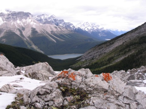
Looking back towards the Spray Lake area and
Goat Mountain Range (photo by Linda)
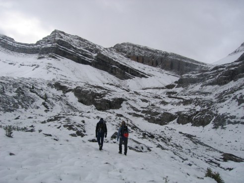
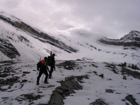
Kevin and Linda approaching Sparrowhawk
Tarns; the ascent route we took went up the snow slope going up and to the left,
starting just right of centre
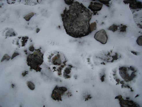
Bear footprints
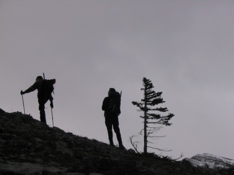
Kevin and I looking up to something (?)
(photo by Linda)
Kevin and I again; the summit of Bogart is
behind the clouds, in the centre of the picture (photo by Linda)
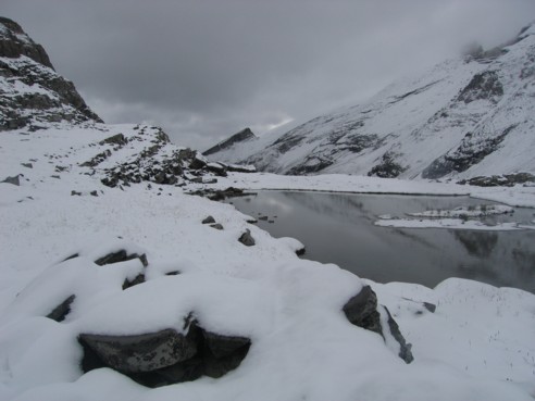
A wintery look at one of the tarns, with
Read's Tower in the centre
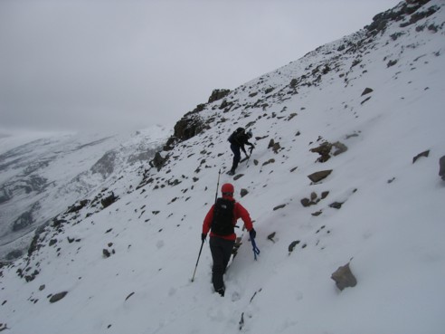
Linda and Kevin, traversing the snow slope
towards the col
Kevin looking for a route up steep rockbands
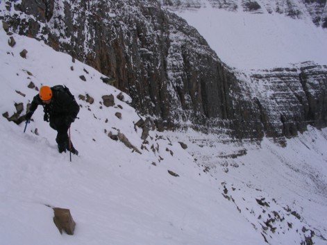
Me, traversing the slope, with some very
high and steep rock walls behind (photo by Linda)
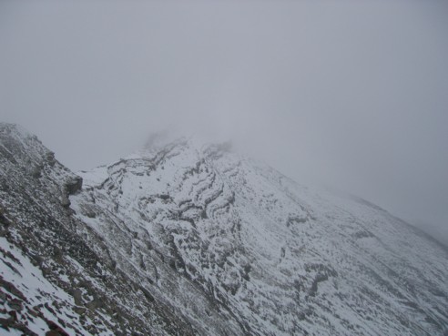
At the col, looking along the west ridge
towards the summit; it's there somewhere!!
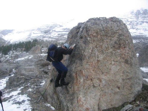
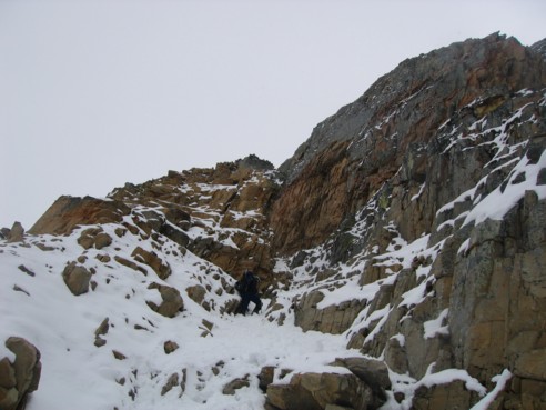
Kevin doing a little bouldering
HOME
SCRAMBLES
MOUNTAINEERING
OTHER
TRIPS
PHOTO
GALLERY
LOG
FAVOURITES
LINKS