PRAIRIE BLUFF (north face route) 2258 m
Rating Easy
Round
trip time 2.5-3.5 hours
Elevation
gain 550 m
Maps 82 G/8 Beaver Mines
The shortest and easiest route to the summit, yet as scenic as the
other routes. Clear skies and late day ascents are recommended for maximum appreciation
of the rock scenery. For a full day, multi-peak baggers could complete this route
after ascending Victoria Peak, Mount Gladstone, or another close by objective.
From Pincher Creek head south towards Waterton.
About 20 km south of the south end of town, turn right (west) onto the Shell
Waterton Complex road (Twp. Rd. 4-3A; the sign is on the east side of the
road). Follow the road for about 9 km, past the complex, and turn left at the
Forest Reserve sign onto Twp. Rd. 4-3. Drive 5.3 km to the gas plant, turning
right just before it. Follow this road for 6.2 km and
then turn left onto an unsigned road. Turn left again 0.2 km later and park in
the open area.
From the parking area, the route is obvious (see photo). Cross the
creek (sometimes dry) and follow it for a few hundred metres. Turn left and up
lightly forested terrain, soon reaching the open slopes of the ascent face.
Head directly up to the prominent rock band above. This rock band
is covered in various vibrant colours of lichens and is a real treat to
explore. There are several easy routes up and through the rock band or more
moderate ones – take your pick.
Above, continue up to the next highpoint, where sits an equally
interesting red argillite rock band and then turn left and hike easily to the
summit.
Return the same way. If you want some variety, it is possible to
descend the bowl west of the ascent route as an alternate descent route.
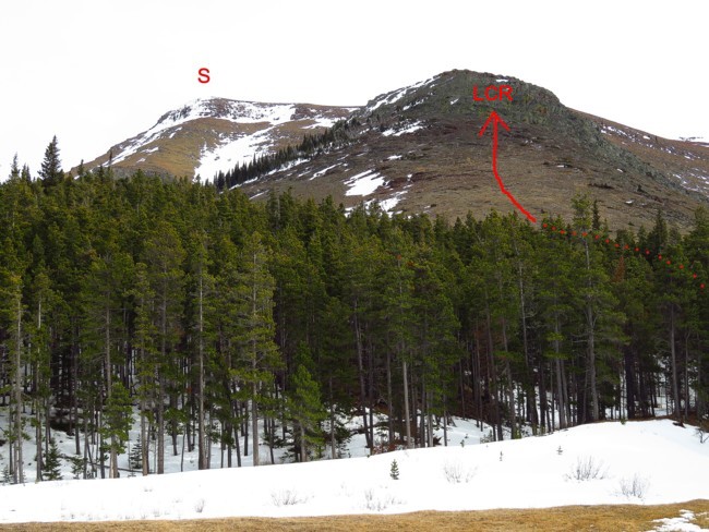 S summit. LCR lichen covered rock band