Crypt Peak via Crypt Lake 2610 m
Rating Moderate via the north ridge
Round
trip time
9.5 hours max for boat route; 11-14 hours for self-propelled route
Elevation
gain 1370 m
Maps 82 H/04 Waterton Lakes, Gem Trek Waterton National Park
Options
for either a mad dash scramble or an adventure kayak and scramble up to as fine
a viewpoint as you could ask for. Taking the scheduled boat and then completing
the scramble can only be done be very fast and fit parties. A longer but more
leisurely route can be completed if you get yourself across the lake with a
kayak, canoe, or raft.
The Crypt Lake hike and the red
argillite summit block of Crypt Peak are amazing! This is simply one of the
best trips you can do in Waterton and is a must- do for experienced scramblers
looking for a challenge. Try from July on. The summit block must be snow-free.
Boat
route: Drive into Waterton and turn left at the
three-way stop. Drive a few hundred metres to where the road forks and turn
left into the marina parking lot. Arrive well before the earliest boat leaves
(check the internet for times) and book that boat. It is preferable to buy the
tickets the day before so that you are ensured a spot on the earliest boat. If
possible, sit at the back of the boat so that you can be first off. Start
hiking immediately and at a brisk pace.
Recommended maximum times for taking for
boat across, assuming arrival at Crypt Lake at 8:50 am:
·
2 hours to Crypt Lake (10:50
am)
·
2.75 hours from Crypt Lake to
summit (1:50 pm)
·
10 minute summit stay (2:00 pm)
·
3.5 hours from summit to Crypt
Landing (5:30 pm)
Self-propelled
route (kayak, canoe, raft): This method should only
be attempted on a calm day with minimal
to no wind and is recommended only for those who have experience boating on
a large lake. Wear a life-jacket and protect any electronic devices in case you
end up in the water.
There
are several places to start your journey. The recommended route is a little
longer than the most direct route, but crosses to the opposite shore at the
lake’s narrowest point and allows you to bail onto the hiking trail that goes
to Crypt landing at multiple points. This route starts just below the Prince of
Wales Hotel. Drive towards Waterton townsite and turn left onto the unsigned
road right before the Cameron Lake turn-off. Drive to the end of the road and
launch your watercraft from here. Paddle over to the opposite shore and then
follow the shoreline, if possible all the way to Crypt Landing (approximately 3.2
km). If the water and wind are making travel difficult, dock your boat at one
of several logical places (there are a couple of bays where the water is likely
to be calmer). Find the hiking trail to the east and follow it south to Crypt
Landing. This trail is sometimes faint and overgrown in places.
For
both routes: Once at Crypt Landing, hike 8.7 km to
Crypt Lake (twice voted by National Geographic as one of the Top 20 hikes in
world). Hike around the left (east) side of the lake to where the trees peter
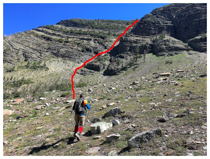
out. Turn left and go towards the steep face that leads to the north ridge and face. Find
the usually dry gully (more to your left) and ascend it all the way to the
ridge (see photo). This gully gets quite steep and challenging higher up. An
easy route to gain the north ridge (one that involves more route-finding) is to
start up the gully, but then veer off to the left and work your way up,
route-finding your way up short rock steps. Do not go too far left as the
terrain gets more serious with steep, exposed scrambling.
Upon
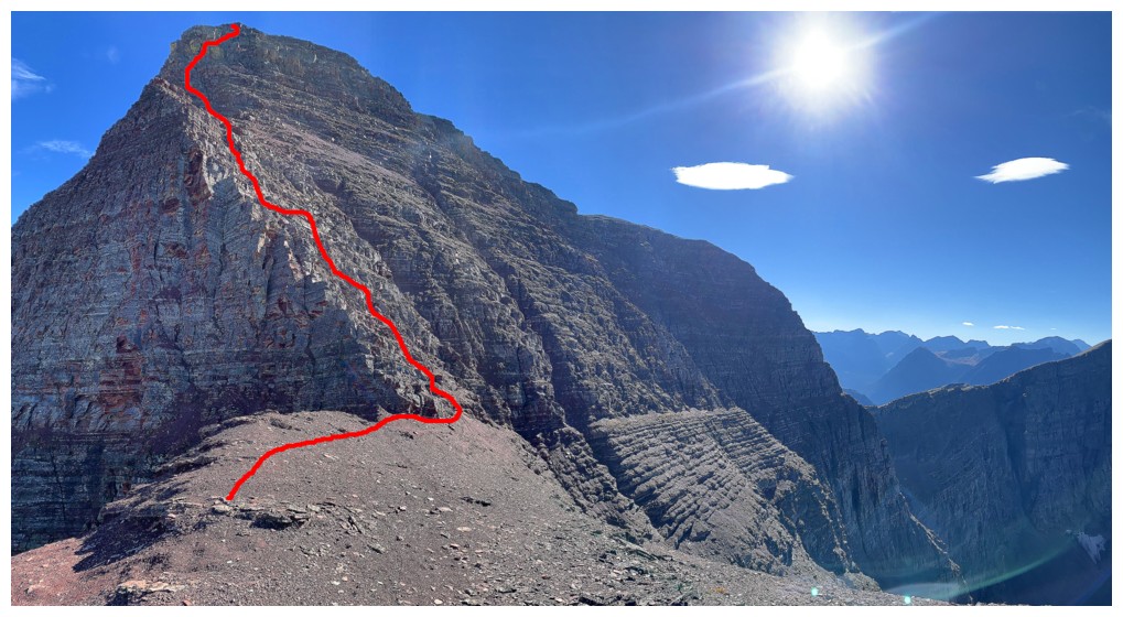
reaching the ridge turn south and follow it up to the red argillite highpoint,
where the intimidating summit block looms in front of you. Surprisingly, with good
route-finding you can weave your way up to the summit, staying relatively close
to the precipitous east face, with only a few moves of moderate scrambling and
some mild exposure. If you end up on difficult exposed terrain, look for
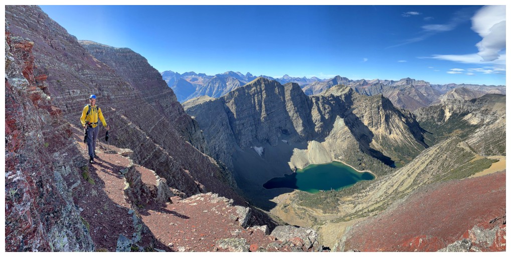
another way up. The vibrantly bright red argillite of this section is one of
the many highlights of the day.
The
summit lies right on the border between Canada and the U.S. and is marked with
a boundary marker. Enjoy the jaw-dropping view for as long as time permits and
then return the same way you came in.
 Route to the ridge, from the back of Crypt Lake
 Route up the summit block


