CRYPT PEAK VIA
VIMY RIDGE 2610 m
Rating moderate
via the northeast and north ridges
Round-trip time 11-14 hours
Elevation gain 1600 m
Maps 82 H/04 Waterton Lakes, Gem Trek Waterton National Park
A long but incredibly scenic route up an
amazing peak that straddles the Canada/U.S. border. Lots of larches en route,
so late September can be a great time to make an ascent. Wait for a clear and
hopefully calm day. Try from mid-July on.
Hike or bike (strongly recommended) the
Wishbone Trail for 7 km. A crossing of Sofa Creek is necessary at the 5.5 km
mark, but is generally easy by mid-summer. Leave your bike at the signed
junction and turn left towards Vimy Peak. Hike the Vimy Peak trail to near its
end (about 4.6 km with approximately 800 m of elevation gain) and look for
another trail that veers off to the left. Take this trail into an open bowl below
the long ridge that connects Vimy Peak to the highpoint of Vimy Ridge.
Hike
up to the nearby ridge on a good, switchbacking trail and continue up to the
main ridge. You are now on Vimy Ridge. Follow the ridge in a southeast
direction, encountering some moderate scrambling with route-finding in short
order. The ridge gets easier after this. Enjoy the ups and downs of the terrain
all the way to a significant highpoint named Mount Arras. The true summit of
Vimy Ridge is the next peak to the southeast.
Descend
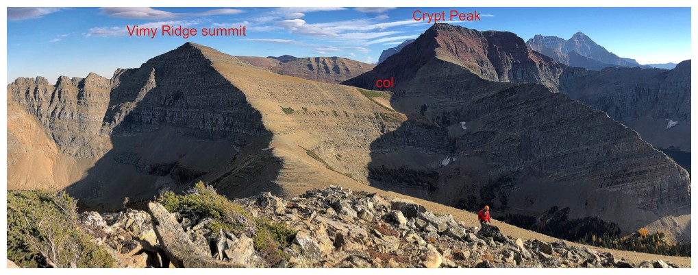
to the Arras/Vimy col and start up towards Vimy. Either go all the way to the
summit and then descend Vimy’s southwest ridge to the Vimy/Crypt col or
side-slope to the same col once some elevation is gained. From the col the
scramble up to the north ridge of Crypt looks a little intimating from below
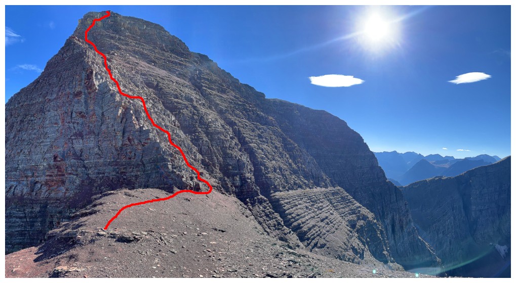
but in fact is quite easy. Upon reaching the ridge turn south and follow it up
to the red argillite highpoint, where the intimidating summit block looms in
front of you. Surprisingly, with good route-finding you can weave your way up
to the summit, staying relatively close to the precipitous east face, with only
a few moves of moderate scrambling and some mild exposure. If you end up on
difficult exposed terrain, look for another way up. The vibrantly bright red
argillite of this section is one of the many highlights of the day. Nearing the
top, stay over to the left (some exposure) and find a good weakness through the
upper rock bands.
The
summit sits right on the border between Canada and the U.S. and provides excellent
views into the lands of our friendly neighbours.
Return
the same way. Again, going to the highest summit of Vimy Ridge is optional.
Resist all other urges to side-slope in order in minimize elevation gains on return
– they are self-defeating.

View towards the objective from near the summit of Mount Arras

Route up the summit block